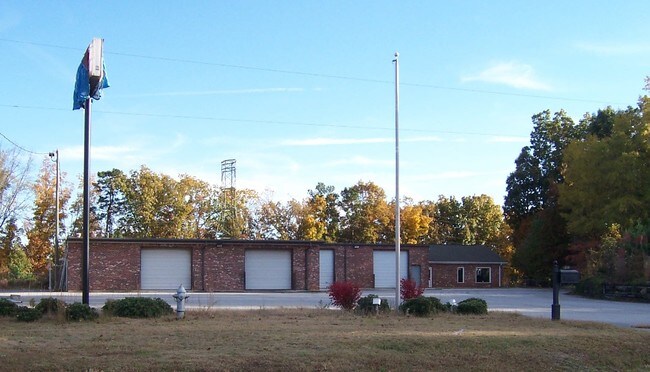
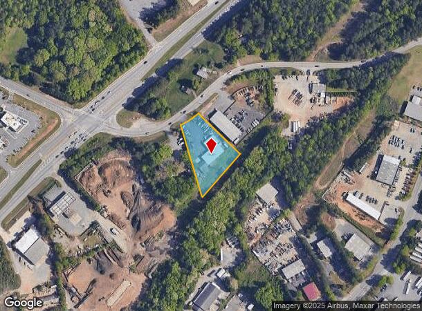
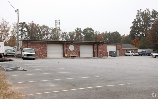
Property Record
259 N Price Rd, Sugar Hill, GA 30518
NEARBY LISTINGS FOR SALE OR LEASE
Property Detail
259 N Price Rd
Atlanta-Sandy Springs-Roswell, GA
John C & Keith Hosch Surv
7-254-042
NORTH PRICE ROAD
Autorepair
Gwinnett
X
Georgia
13135C0024G
2
2025
1.17 AC
2025
Duluth/Suwanee/Buford
050241
Atlanta
9,550 SF
DEMOGRAPHICS near 259 N Price Rd
1 Mile
3 Mile
5 Mile
2024 Total Population
5,123
62,960
156,094
2029 Population
5,323
66,329
165,952
Pop Growth 2024-2029
+ 3.90%
+ 5.35%
+ 6.32%
Average Age
38
38
38
2024 Total Households
1,641
20,533
51,786
HH Growth 2024-2029
+ 3.96%
+ 5.52%
+ 6.38%
Median Household Inc
$106,944
$113,476
$103,825
Avg Household Size
3.10
3.00
3.00
2024 Avg HH Vehicles
2.00
2.00
2.00
Median Home Value
$401,585
$373,353
$372,105
Median Year Built
1998
2000
2000
Nearby Places
Map Layers
Map Styles
 Street
 Aerial
- Restaurants
- Banks
- Shops
- Fitness
- Groceries
PUBLIC TRANSPORTATION
AIRPORT
Hartsfield - Jackson Atlanta International
DRIVE
WALK
Distance
Hartsfield - Jackson Atlanta International
58 min
43.9 mi
Nearby Properties
Address
Land Use
TOTAL SIZE
Lot Size
Zoning
Address
Land Use
TOTAL SIZE
Lot Size
Zoning
629,478 SF
1.54 AC
BG
Address
Land Use
TOTAL SIZE
Lot Size
Zoning
534,578 SF
44.21 AC
RM8
Address
Land Use
TOTAL SIZE
Lot Size
Zoning
393,939 SF
42.21 AC
RM8
Address
Land Use
TOTAL SIZE
Lot Size
Zoning
419,467 SF
665.75 AC
RZT
Address
Land Use
TOTAL SIZE
Lot Size
Zoning
488,895 SF
7.50 AC
OI
Address
Land Use
TOTAL SIZE
Lot Size
Zoning
330,562 SF
29.62 AC
RM13
Address
Land Use
TOTAL SIZE
Lot Size
Zoning
379,183 SF
6.09 AC
PMUD
Address
Land Use
TOTAL SIZE
Lot Size
Zoning
368,594 SF
2 AC
Address
Land Use
TOTAL SIZE
Lot Size
Zoning
384,000 SF
23.08 AC
BG
Address
Land Use
TOTAL SIZE
Lot Size
Zoning
431,273 SF
11.68 AC
BG
Address
Land Use
TOTAL SIZE
Lot Size
Zoning
521,231 SF
46.16 AC
HM1
Address
Land Use
TOTAL SIZE
Lot Size
Zoning
151,663 SF
42.77 AC
BG
Address
Land Use
TOTAL SIZE
Lot Size
Zoning
370,414 SF
14.34 AC
PMUD
Address
Land Use
TOTAL SIZE
Lot Size
Zoning
313,869 SF
12.19 AC
RM24
Address
Land Use
TOTAL SIZE
Lot Size
Zoning
447,399 SF
25.71 AC
GCA
Address
Land Use
TOTAL SIZE
Lot Size
Zoning
240,556 SF
49.13 AC
HM1
Address
Land Use
TOTAL SIZE
Lot Size
Zoning
461,700 SF
43.77 AC
C2
Address
Land Use
TOTAL SIZE
Lot Size
Zoning
367,756 SF
12.04 AC
RM
Address
Land Use
TOTAL SIZE
Lot Size
Zoning
332,011 SF
8.84 AC
PMUD
Address
Land Use
TOTAL SIZE
Lot Size
Zoning
144,000 SF
21.13 AC
RM
Address
Land Use
TOTAL SIZE
Lot Size
Zoning
6,552 SF
235.95 AC
R140
Address
Land Use
TOTAL SIZE
Lot Size
Zoning
204,436 SF
16.28 AC
BG2
Address
Land Use
TOTAL SIZE
Lot Size
Zoning
496,608 SF
29.68 AC
C2
Address
Land Use
TOTAL SIZE
Lot Size
Zoning
379,104 SF
20 AC
OI
Address
Land Use
TOTAL SIZE
Lot Size
Zoning
3,232 SF
66.63 AC
OI
Address
Land Use
TOTAL SIZE
Lot Size
Zoning
184,890 SF
3 AC
PMUD
Address
Land Use
TOTAL SIZE
Lot Size
Zoning
408 SF
217.12 AC
R100
Address
Land Use
TOTAL SIZE
Lot Size
Zoning
544,900 SF
46.95 AC
M1
Address
Land Use
TOTAL SIZE
Lot Size
Zoning
185,524 SF
12.61 AC
M1
Address
Land Use
TOTAL SIZE
Lot Size
Zoning
119,188 SF
5.28 AC
BG
The World's #1 Commercial Real Estate Marketplace
Connect with us
© 2026 CoStar Group
The information above has been obtained from sources believed reliable. While we do not doubt its accuracy we have not verified it and make no guarantee, warranty or representation about it. It is your responsibility to independently confirm its accuracy and completeness. Any projections, opinions, assumptions, or estimates used are for example only and do not represent the current or future performance of the property. The value of this transaction to you depends on tax and other factors which should be evaluated by your tax, financial, and legal advisors. You and your advisors should conduct a careful, independent investigation of the property to determine to your satisfaction the suitability of the property for your needs.